If you're a regular Atlas user, you may have noticed links to "Add Wikipedia Content" in the results of certain location searches. That was our first version of Wikipedia integration with Atlas (using the Futef API).
This week we improved the integration. Instead of offering Wikipedia results to certain searches, we now have a Wikipedia search tab front-and-center on the Atlas homepage.
This means you can add any geocoded Wikipedia content to your map. Run a search, click "Map This Result", and you're done. As with local search, your search is restricted to the area you have displayed on the map -- zooming out broadens the search, zooming in narrows it.
Thursday, April 12, 2007
Tuesday, April 10, 2007
The Weather in Altas
Weather is a sore subject in Boston this time of year. Spring is around the corner, but winter clings on into April.
To help folks get a better grasp on what's going on outside, we've added weather data from weather.gov to Atlas. By checking a box in the "Edit Map Properties" menu, you can now add three-day forecasts for U.S. points (international weather is not supported).
As an example, I put together this map of weather around New England:
Note that the weather is updated on the fly, so you'll have up-to-date forecasts as long as your map is live.
Enjoy, and let us know if you have any questions.
Monday, March 5, 2007
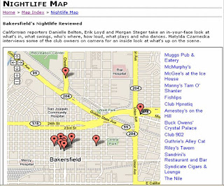
Sidebar in Action in Bakersfield
If you'd like to see a great example of our new sidebar feature in action, check out this nightlife map the Bakersfield Californian launched last week.
Wednesday, February 28, 2007
Sidebar Update
Thanks to feedback from our friends at The Bakersfield Californian, we've made a couple tweaks to the sidebar feature we released yesterday. Most importantly, it's now possible to display the sidebar on the side of maps [insert ironic joke here]. To see what this looks like, check the new version of the map from yesterday I saved here.
Also, if there was some stray code showing up in your sidebar yesterday it should be gone today.
Also, if there was some stray code showing up in your sidebar yesterday it should be gone today.
Tuesday, February 27, 2007
Introducing the Altas Sidebar
Last night we launched a cool new feature: sidebars. Now when you create a map with a bunch of different points, you can display titles for all your data in a table beneath the map (thumbnails are also displayed under wider maps). When you click on a title or thumbnail, the corresponding info window will open on the map.
To show you how this works, I put together this map of notable Central Square institutions with some pictures I took this morning. If you want to see how the thumbnails work, there's a wider version of the map here.
One last thing: You probably noticed that the map above includes an ad. All maps that use the sidebar feature will include an add. Basic maps that don't use the sidebar feature will still be ad-free.
Wednesday, February 21, 2007
Atlas in Drupal? You Bet.
A few people have written wondering how to get Atlas working in Drupal. Earlier this week InsideVandy, the web site of Vanderbilt University's student newspaper, showed how it's done, launching this map on their site.
If you have problems getting Drupal to work on your site, you may have to add Atlas to your embed filter. For more about the embed filter, see Drupal.org here and here. And, of course, you can always get in touch with me.
If you have problems getting Drupal to work on your site, you may have to add Atlas to your embed filter. For more about the embed filter, see Drupal.org here and here. And, of course, you can always get in touch with me.
Thursday, February 15, 2007
Snow (and Atlas) Cover Boston
I've been posting a lot about Atlas' new photos features. Yesterday Boston.com published a great example of these features in action.
As part of their Valentine's Day blizzard coverage, they created an Atlas map that allowed their users to contribute snowy photos of dogs, robins, backyards and Valentines. You can see the map here or see an image of it below.

We're very excited about this map and other like it. Sites like Panoramio and Yahoo's World Explorer show how naturally maps and photos go together. There's lots of work left to do, but hopefully Atlas' new photo features make it possible for publishers to create similar photo communities on their own sites.
Give it a try, and if you have questions, let us know.
As part of their Valentine's Day blizzard coverage, they created an Atlas map that allowed their users to contribute snowy photos of dogs, robins, backyards and Valentines. You can see the map here or see an image of it below.
We're very excited about this map and other like it. Sites like Panoramio and Yahoo's World Explorer show how naturally maps and photos go together. There's lots of work left to do, but hopefully Atlas' new photo features make it possible for publishers to create similar photo communities on their own sites.
Give it a try, and if you have questions, let us know.
Wednesday, February 14, 2007
Pictures of The Gates (With New Photo Features)
Last night I came across a set of pictures I took two years ago when The Gates were up in Central Park. I've published them on the map below to illustrate a few tweaks we made to Atlas' photo-upload feature yesterday. (If you don't see the map, click through here.)
Here's a list of the key tweaks:
> We've increased the size of the thumbnail displayed in the info window to 200 pixels on the longest side (we maintain the dimensions of photos uploaded, so one side will probably be smaller)
> We've added a [+] next to thumbnails in the info window to show people that they can click through to a larger version
> We're resizing the larger version of the photo so it fits on people's screen and loads quickly.
These changes were suggested by our friends at Boston.com. If you have suggestions, please let us know. We'd love to hear from you.
Monday, February 12, 2007
How Do I Moderate?
Lots of folks using Atlas' user-contribution function ask us about the moderation feature.
If you want to let your readers contribute to your map, but are concerned about things getting out of hand, select "Moderate User Contributions" in the "Edit Map Properties" popup. When this option is selected, contributions or edits from users will be held in a queue for you to review before showing up on the live site.
To review and publish contributions in the queue, go to the edit screen of your moderated map and select "Moderate" from the list of links in the upper right corner of the map. Here's what it looks like:

Thursday, February 8, 2007
Where to Tango in Italy
One of the well-documented pleasures of building a web service is its unexpected uses. You never know who's going to find your site, and you never know how they're going to use it.
One of our favorite recent surprises is the popularity of Atlas on the Italian tango site Tanghéri. The folks in charge of this site published a map of places to Tango. (I don't speak Italian, so I'm guessing they're places to Tango.) They opened the map up for users to contribute, and have been getting a consistent stream of contributions for the past few weeks. Here's what it looks like:

If you're thinking about experimenting with the user contributions feature, this is a great site to check out -- even if you can't speak Italian.
One of our favorite recent surprises is the popularity of Atlas on the Italian tango site Tanghéri. The folks in charge of this site published a map of places to Tango. (I don't speak Italian, so I'm guessing they're places to Tango.) They opened the map up for users to contribute, and have been getting a consistent stream of contributions for the past few weeks. Here's what it looks like:
If you're thinking about experimenting with the user contributions feature, this is a great site to check out -- even if you can't speak Italian.
Wednesday, February 7, 2007
Your Photos, Now on the Map
About a year ago I spent some time traveling around South America with my sister. One of the highlights of the trip was a day we spent climbing to the top of Volcan Villarrica in southern Chile -- and more specifically, the 20 minutes it took to slide down the side of the volcano on our butts.
Using the new photo upload feature we added to Atlas yesterday, I just created a map of the area around Villarrica and added a few of my photos. You can see them in the infowindows when you click on the pins. Make sure you click on the thumbnails to see the full-sized images.
Also, if you click through to the map, you'll see that I enabled the user contributions. The photo upload feature works for map users the same way it works for map owners, so if you have pictures of Villarrica you can add them here too.
Tuesday, February 6, 2007
Cambridge Burgers Via Google Local Search
This morning we added a very cool new feature to Atlas: Google Local Search.
Now, if you want to map your favorite place to get a burger, you switch to the "Business Name" tab and enter the name. Atlas will restrict its search to the area visible on the map, so if you're zoomed out, you may have to enter the city and state. If you're already zoomed in on a specific area, just the business name should be fine.
Here's what it looked like when I searched for "Cambridge Common, Cambridge, MA":

Here's a map of burger joints in Cambridge. Feel free to add your favorites.
Update: In the comments, David Silver asked whether we were going incorporate civic institutions as well as just businesses. The answer is that the "business" search returns quite a few civic institutions. I added the main Cambridge Public Library and the Mayor's Office to this map.
Sunday, February 4, 2007
2269 Dan Marino Boulevard, Miami Gardens, FL
The Patriots will be watching the Superbowl at home today. So, like Barack, I'm routing for the Bears when they take on the Colts at Dolphin Stadium in Miami this evening.
Thursday, February 1, 2007
Aqua Teen Hungerforce & Video in Atlas
It's been a surreal day and a half here in Boston. Yesterday the whole city shut down because of a bomb scare that turned out to be guerilla marketing for the Aqua Teen Hungerforce (ATHF) tv show -- the suspicious objects were neon ATHF lights.
Boston.com has more on the absurdity here (including this Atlas map of all the "bomb" locations).
The artists who created the ATHF lights recorded the process on video, so this is a good opportunity to point out that it's very easy to add video to Atlas maps. You just add the video's embed code to your infowindow, then change the infowindow dimensions to fit your video (this option is listed under "Edit Map Properties").
Here's an example with the video of the lights going up. I can't embed the map into this page because I had to make it wider than the Blogger template in order to fit the video.
Monday, January 29, 2007
Does Your Map Fit?
Every so often we see maps that get cut off by the side of a blog or a site template.
It's very easy to fix this problem -- all you need to do is change the map dimensions ("Width" & "Height") in the "Edit Map Properties" popup. That's what I'm doing in the image below. You can change the map to fit just about any template.

For example, this link goes to a huge satellite image of central Moscow. By changing only the width and height, I've embedded two very different versions of the map to this page. (I could have embedded the big image on the page if the Blogger template accommodated 800-pixel-wide images.)
Here's a 400 x 400 version of the image centered on the Kremlin:
And here's a 400 x 2000 version -- a slice of Moscow from one side of the garden ring to the other:
Sunday, January 28, 2007
Set Your Atlas Start Page
Here's a tip for folks using Atlas to create a lot of maps of the same region: If you navigate to the region you typically map, open "Edit Map Properties" and click "Set Default", your Atlas account will always open new maps on the default you set.
Our default default is North America, so this will be particularly useful to our European, Asian & Latin American users.
Here's a screen grab of me setting my default to Mauritius (I was reading about Dodos this weekend in the New Yorker).

One other note: Thanks to the folks at the Ball State Daily News, we've discovered that Atlas edit windows aren't appearing in Safari. I'll let you know when this is fixed.
Saturday, January 27, 2007
A Few Hiccups
Atlas traffic shot up this week after we were picked up by a few blogs in Europe and China. Though we're working on some changes that should make Atlas easier to use, we've been happy to see that the tool is intuitive enough for non-English speakers to figure it out.
We've had a few hiccups handling all this new traffic. Atlas was down during brief periods of heavy use yesterday and again today. We're working to make sure this doesn't happen again, and that we're prepared for continued growth.
We apologize for any problems this caused folks.
As always, please let me know if you have any questions or feedback for us.
Tuesday, January 23, 2007
Accented Characters Now Work
Good news! After a lot of work, Theo pushed live a change this evening that should fix problems handling accented characters.
If you continue to encounter problems, please let us know.
To test the changes, I put together this map highlighting four of my favorite cities with accented or non-Latin characters in their names.
If you continue to encounter problems, please let us know.
To test the changes, I put together this map highlighting four of my favorite cities with accented or non-Latin characters in their names.
Monday, January 22, 2007
Using the CSV Function
We've had a few questions about adding different icons to an Atlas map.
When you're adding points by hand or the search box, you can add new icons by changing the settings under "Edit Map Properties."
The same things works with the CSV function. That's how I created the map below.
First, I uploaded the red icons, using this basic csv file:
"215 Court St, Brooklyn, NY",Joya,Thai food with a DJ in Cobble Hill
"187 Atlantic Ave., Brooklyn, NY 11201",Sahadi's,Good Middle Eastern groceries
11201,Brooklyn,Brooklyn Heights
Brooklyn
Once those points were on the map, I switched the settings to green icons, and added this csv file:
"138 Bergen St.,Brooklyn, NY",Brooklyn Inn
"79 Hoyt St, Brooklyn, NY 11201",Kili
For another example that uses multiple icon-types, check out Baristanet's map of teardowns in Montclair, NJ.
One word of warning: If you start deleting and re-uploading points via the csv function, you may find funky overlapping icons. This is a bug, and it's on our list.
Friday, January 19, 2007
User Contributions vs Wiki Editing
One of the coolest things about the new user contributions feature is wiki editing -- you can actually put up a map and have your community edit it like they would a text-based wiki. As the map owner, you can moderate all of the contributions.
This is a difficult concept to explain in the tool itself, especially since we're trying to avoid clutter and keep Atlas super-clean.
To demonstrate the difference between the two types of editing, I'm posting another version of the Northeastern University map I posted on Tuesday. The one in today's post is identical to the one in Tuesday's post, except wiki-editing is enabled (this option is listed under "Edit Map Properties").
If you click "Contribute to This Map" on the map in this post, you'll see you can click on any point on the map and edit it. In the map from Tuesday, you can still "Contribute to This Map", but you can only add points. You can't edit existing points.
Tuesday, January 16, 2007
Best Food, Coffee & Beer Near Northeastern
Tomorrow, thanks to the help of Dan Kennedy, I'm doing Atlas user testing at Northeastern University. I'm going to ask everybody to add their favorite bar, restaurant or coffee shop to this map.
Monday, January 15, 2007
Allen's Pond, Dartmouth, MA
A while back Pito Salas clued me in on the beauty of posting simple satellite pictures. This is Allen's Pond near where I grew up in Dartmouth, MA. I was down there this weekend.
Welcome to A.M.O.T.D
Hi! Glad you've found our new blog.
Our plan is to keep this a very simple page about Atlas and all the great things you can do with it.
We'll mostly be posting maps -- some that we've created, some that Atlas users have created and some from other places.
Don't take the name of this blog too literally -- for the time being we expect to be posting three or four times a week.
That's it. Enjoy the maps, and make sure you let us know if you have questions or feedback. We'd love to hear from you.
Subscribe to:
Posts (Atom)

